Gulf of Maine Climate

September would have been a dry month for most of the region if not for two storms that brought heavy rainfall. Due to the storms, some areas ended September with nearly three times their normal rainfall. On September 11, a slow-moving low pressure system dropped up to 100 mm (4 in.) of rain, with the greatest amounts in southern New Brunswick. Along the Bay of Fundy coast, local rainfall rates exceeded 35 mm (1.4 in.) per hour. The storm caused flash flooding in Fredericton and Saint John. From September 29 to October 1, tropical moisture fueled a stalled front and low pressure system, which dumped 100 mm (4 in.) to 250 mm (10 in.) of rain on parts of Maine, New Brunswick, and Prince Edward Island. Local rainfall rates were around 35 mm (1.4 in.) per hour. Numerous roads and bridges were washed out or closed. More than 400 New Brunswick locations were damaged, with some roads still closed as of early December. The Department of Transportation and Infrastructure estimated repairs would top $15 million in the province. Coastal flooding was made worse by high tide in Portland, ME, which had its second all-time wettest September day. The heavy rain also caused the Maine coast to be closed to shellfish digging. In addition, wind gusts up to 119 km/h (74 mph) downed trees, leading to tens of thousands of power outages. Several New Brunswick and Maine schools were closed.
A powerful storm associated with the remnants of Hurricane Patricia brought strong winds and heavy rain to the region from October 27 to 29. In Washington County, ME, sustained winds of 64 km/h (40 mph), with gusts to 106 km/h (66 mph), were reported. Downed tree limbs led to power outages for more than 25,000 customers in Maine, New Brunswick, and Nova Scotia. Strong winds, large waves, and high tide resulted in flooding and erosion along the Bay of Fundy coast. A barge flipped over in high waves near Saint John, NB. Rainfall from the event totaled up to 100 mm (4 in.).
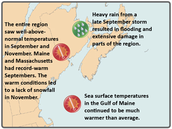
On November 23, a storm brought strong winds and up to 100 mm (4 in.) of rain to southern New Brunswick, Nova Scotia, and Prince Edward Island, while up to 13 cm (5 in.) of snow fell in northern New Brunswick. The heavy rain led to shellfish closures for parts of the Northumberland Strait and the north shore of Prince Edward Island. Heavy rain from a late September storm resulted in flooding and extensive damage in parts of the region. The entire region saw well-above-normal temperatures in September and November. Maine and Massachusetts had record-warm Septembers. The warm conditions led to a lack of snowfall in November.
Eleven high temperature records were set in New Brunswick on September 7, while Boston, MA set record highs on the 8th and 9th. Woodstock, NB and Portland, ME had their warmest Septembers on record. November’s warmth contributed to New Brunswick receiving only 26% of normal snowfall for the month, Caribou, ME seeing only 36% of normal snowfall, and many other U.S. sites receiving no measurable snow.
The 2015 Atlantic hurricane season featured eleven named storms, which was below average. However, four named storms entered the Canadian Hurricane Centre Response Zone, which was near the annual average.

Dryness and Warmth
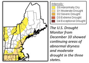
Abnormal dryness and moderate drought, which began in spring and continued though summer, lingered through fall in parts of Maine, New Hampshire, and Massachusetts. Falling water levels in wells, reservoirs, lakes, and waterways led to voluntary water restriction in several New England towns. In late September, two Maine counties were declared natural disaster areas due to damages and losses caused by drought.
Prolonged warmth in September delayed the onset of the fall foliage season by up to two weeks for the entire region and extended the growing season in New Brunswick. Weather conditions were generally good for field work and harvest. The warm temperatures helped pumpkins ripen early in some areas, but delayed color development in cranberries and a few apple varieties. The warmth also delayed the Maine potato harvest by a few days as it was too warm to store potatoes. Many crops, especially pumpkins, apples, and potatoes, were expected to be abundant and of high quality.

Ocean Warming
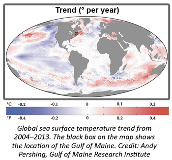
A recent report in Science identified the Gulf of Maine as one of the fastest warming regions of the global oceans and linked the warming to the decline in the region’s cod fishery. The authors found that the Gulf of Maine warmed three times faster than the global average rate since 1982. Between 2004 and 2013, the rate in the Gulf of Maine was faster than 99.9% of the global ocean. The study found that rising water temperatures reduced the productivity of cod stocks, and that not accounting for the productivity change led to fishing quotas that were too high. Gulf of Maine cod are now at record low levels and quotas are so reduced that fishermen must now avoid cod.
The rapid warming in the northwest Atlantic has been linked to changes in the distribution of many ocean species. Over the last several years, scientits have reported seeing fewer critically endangered right whales in their traditional feeding grounds in the Bay of Fundy. Right whales come to the Gulf of Maine to feed on a particular cold-water zooplankton species, leading to speculation that warm waters may have reduced the abundance of the whales’ favorite food. Fishing and shipping regulations in the Gulf of Maine have been designed to protect right whales. During summer 2015, scientists searching for right whales outside their traditional feeding grounds found a surprising number of the whales in the Gulf of St. Lawrence.
For more information, visit www.drought.gov/drought/content/resources/reports and www.ec.gc.ca/eau-water/default.asp?lang=En&n=F2BDD611#regionalclimateoutlooks.

