Vol. 10, No. 10  October 2005    News & Comment for and by the Fishermen of Maine          SUBSCRIBE NOW!!
Homepage    Archives    Subscriptions    Advertising
Hurricanes’ Net Loss
by Niaz Dorry

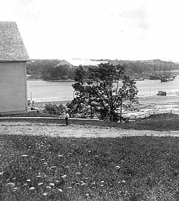
Please do not look to my life, but take me even as a lamppost on the road that indicates the way, but cannot walk the way itself.”
— Gandhi

Within almost exactly eight months to the day of the Indian Ocean tsunami, the world’s fishing communities find they are once again mourning great losses; this time back-to-back hurricanes, Katrina and Rita.

In the Gulf of Mexico, on August 29, Katrina devastated fishing communities along the three states of Alabama, Mississippi, and Louisiana. Two weeks later, Texas felt the wrath of Rita, as did Louisiana.

Preliminary reports put the number of lives lost in the thousands, depending on the source. Assessments of infrastructure, fishing boats, and other personal losses, however, appear to reach into the billions of dollars.

Mississippi, for example, didn’t fare well when Katrina made landfall. According to Mississippi Department of Marine Resources’ preliminary assessment, 100 percent of fishing piers in the coastal areas were either destroyed or severely damaged by


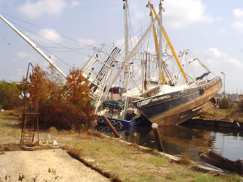
In the affected area from the Alabama/Mississippi border to the Louisiana/Texas border, 10 - 15,000 boats are affected.” Photo: Scott Labak

Katrina. The few boats that were spared found themselves without a port or other type of safe harbor. Ironically, one year ago, the State was breathing a sigh of relief as it seemed that they had been spared by hurricane Ivan by being on its “good side.”

Katrina wasn’t as kind; entire coastlines of Mississippi, Alabama, and Louisiana were in her path.

So widespread was the devastation that on September 9 the U.S. Department of Commerce declared a formal determination of failure in the fisheries of the Gulf of Mexico due to the flooding and destruction. Such a determination allows for provisions of the Magnuson Fishery Conservation and.

continue


Life Along The Kennebec
by Mike Crowe

Most people today see big rivers while driving over them on bridges or on roads that parallel them. Maine has many rivers, five of the larger, more known are the Saco, Androscoggin, Daramiscotta, Kennebec and Penobscot. Most of Maine’s rivers were a part of what Maine has been most known for – fishing, lumber and boatbuilding. To know a big river, it is necessary to stand on its bank, to be on a small boat floating on its great mass of moving water, to feel the lazy drifter of August and the hulking giant of April. The power in a river has long been apparent to humans who have witnessed it. Native Americans saw it as the river’s spirit; some Europeans saw it as a force to capture and transform.

Native Americans used the rivers for short and long distance travel. Tributaries of the big rivers led upstream to lakes, then smaller streams to portages and on to other streams and rivers in a network which covered a large part of the state. Activity today on most is limited to a few ships and some recreational boats in August. Native Americans sailed down Maine’s rivers to spend the summer fishing at the coast, but it was


continue

Capable of hitting 33 miles an hour, the 80 foot runner Maybe operated very successfully in Buzzard’s Bay. She had a draft of four and a half feet and a beam of 16 feet. Fuel capacity was 1,500 gallons. She was built in Southwest Harbor, Maine. Photo printed with permission of National Fisherman


archivessubscribeadvertising


This site hosted by IslandWeb - Bar Harbor, Maine. © 2000
Dynamically presenting Acadia and Maine to the Entire World

Web Applications @ ShadIsland.com