
Fort Pownall
by Tom Seymour
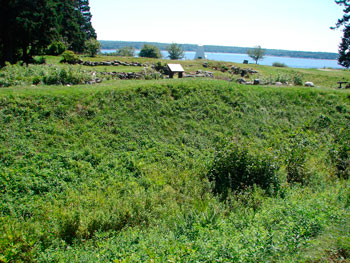
Remains of Fort Pownall at the end Fort Point peninsula in Stockton Springs. The fort was built in 1759 during the French and Indian War. In the foreground is the ditch which formed a moat around the fort. On the ridge above the ditch was a thick wood wall. Beyond that, the remnants of the foundation of the central wooden building, a more recent white lighthouse, upper Penobscot Bay and Castine on the horizon. Tom Seymour photo
By 1758, the French and Indian War, decades long, had taken its toll, physically, emotionally and financially on the people of Maine. In that year, the fort at St. George was attacked by a combined band of 400 French and Indians.
Fortunately, Colonial governor Pownall (for whom the town of Pownalborough was named) was able to send aid in the form of 300 men as reinforcements. This prevented the enemy from gaining any advantage and they eventually withdrew without ever taking the fort.
An agitated and vengeful enemy next attacked the fort at Friendship, where they succeeded in killing and capturing eight men. They were unable to take the fort, however, and as they were compelled to do at St. George, withdrew without a prolonged siege. This was the last significant Indian attack upon Maine people. But, of course, no one knew that then. Fear of further attacks and attending butchery spread far and wide.
Fort Proposed
Also, since war raged on and the French and Indian forces were concentrated north of Maine in eastern Canada, Governor Pownall decided that a fort was needed at the mouth of the Penobscot. He reasoned that, “As the British Crown has secured and fortified St. John’s River, the enemy has now no other outlet to the sea than through the Penobscot River, the door being shut upon them in every other part.”
Pownall’s proposal was approved by the colonists as well as the British Crown. Accordingly, Pownall was authorized to secure the services of 400 men to take possession of the Penobscot Region and establish a fort there. In May, 1759, Pownall, along with General Samuel Waldo (for whom the towns of Waldo, Waldoboro and the county of Waldo were named), a proprietor of the Muscongus, or Waldo Patent, sailed from Boston in early May. The mouth of the Penobscot in what is now the town of Stockton, was within the boundaries of the Waldo Patent, thus General Waldo’s strong interest in the place.
On May 15, Governor Pownall met with a group of Indians near present-day Belfast, at the mouth of the Passagassawaukeag River. Pownall advised the natives that he was going to build a fort at the mouth of the Penobscot and he desired that they should become friends and trading partners. Along with advising his listeners of the penalties that would ensue for failing to comply with his admonitions, he made presents of ammunition, rum and food.
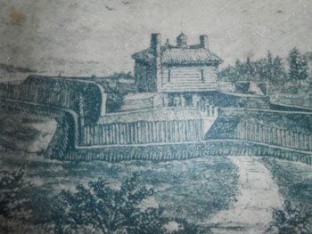
Fort Pownall with drawbridge in the foreground from an engraving of unknown date or origin. The angle of view is similar to that in the photo above. In 1759 it’s location, the moat, pickets, thick wood walls, cannon, and protected firing positions left it unchallenged.
Land Claim
After that, Pownall reached Wasaumkeag Point, currently Fort Point, and established a camp.
However, as ideal as this location seemed as a place for a fort, Governor Pownall was not content to begin construction until he also searched the surrounding area for an even better situation. So with 136 men, he sailed up the Penobscot to near the present City of Brewer.
There, on the east side of the river, he ascended the tallest hill he could find and took possession of the country all around in the name of the king. Then, after a brief ceremony, he buried a lead plate with the inscription: “May 23, 1759. Province Massachusetts Bay, Dominions of Great Britain. Possession confirmed by Thomas Pownall, Governor.”
Governor Pownall’s act of claiming this land east of the Penobscot carried much weight in later years, since it established an English and colonial presence there. Thus in 1783, at the Treaty of Paris, the boundary for the United States was settled as the St. Croix River rather than the Penobscot, as the British would have had it. It was none other than John Adams who submitted the record of Governor Pownall’s claim to land east of the Penobscot that settled the issue.
Fort Built
After the lead plate was buried, General Waldo was taken with an “attack of apoplexy” and died. Governor Pownall immediately sailed back to Fort Point and the following day, buried General Waldo’s body with religious services as well as a military ceremony. The body was since exhumed and removed to the King’s Chapel Burying Ground in Boston. Waldo was a Boston native, so that seemed fitting.
Incidentally, some folklore has it that General Waldo died at the fort after looking the land over and saying, “This is my bound.” But in fact, Waldo died further up the Penobscot, as mentioned above.
The fort, however, was built and it became a substantial structure, more than adequate to intimidate an enemy of that day. Specifically, it was of a square form, with a parapet and a water-filled ditch 15 feet wide on top, five feet wide on bottom and eight feet deep. On each corner stood a 33 feet square flanker and in the center was the two-story blockhouse, 44 feet square, with a sentry box on top. The top section of blockhouse slightly hung over the lower section. The blockhouse had two chimneys, one at each end.
Cannon were placed between the breastwork and the blockhouse. These commanded a good section of river, making it difficult for an enemy to affect passage. An engraving was made after a description of the fort by Joseph P. Martin, as was a floor plan of the fort. Martin, in turn, got his information from someone who had lived at the fort. Historians agree that this information is most certainly accurate, it being quite detailed.
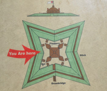
Photo of ground plan of Fort Pownall from information panels at the state park. Tom Seymour photo
The fort, completed on July 28, 1759, served well its purpose as a defensive outpost. It was never attacked, which says much about its effectiveness. A garrison remained in place at the fort up to the Revolutionary War.
However, despite its static, rather than active, military role, the fort served as a trading center for colonists and Native Americans. They, in fact, entered into a never-broken treaty of friendship with the colonists. After that, a building was erected at the fort to accommodate visiting Native Americans. Trade in furs flourished there.
Also, officer’s quarters were erected between the fort and the river. The stone floor and parts of foundation were discovered and partially excavated in recent times and are visible to visitors there today.
In March of 1775, the fort’s loyalist commander Colonel Thomas Goldthwait, clandestinely directed British Captain Mowatt to come in at night and dismantle the fort, which Mowatt did by removing the cannon and all ammunition. Angered by this and determined to prevent British occupation of the fort, American forces burned the blockhouse and filled in the ditches.
Soon after this, Goldthwait was deposed and possession of the fort was assigned to Colonel Jonathan Buck of Bucksport. Goldthwait quickly joined the British and escaped to loyalist-occupied Halifax.
Today the ditch (since excavated) and much of the foundation of Fort Pownall sit in an open, grassy area at Fort Point State Park. This somewhat off-the-beaten-path park does not see the volume of traffic common to other state parks. It is possible to go to the fort, walk the perimeter, go inside what was once the enclosure and listen for the voices and footfalls of those who lived there at a time of much change in the early days of Maine.
A modern-day lighthouse, only recently converted from being manned by a lighthouse keeper and family to an electric light and horn, sit near the fort. And just past this, stands the old bell tower, on the very edge of a precipice bounding the Penobscot River. Views of neighboring Hancock County are spectacular, as is the sight of much of Penobscot Bay looking to the southeast. Standing here, it’s easy to see why visionary men of old chose this location for a fort meant to protect not only Maine but also the other colonies during a long and bloody war.