
Coastal Maine Place Names
Amateur Historians Can Dig Up the Past
by Tom Seymour
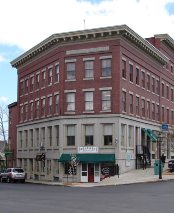
Axel Hayford, born in Windsor, 20 April, 1814, resided in Belfast from 1840 to 1883. An active man he had charge of the poor, been Deputy Sheriff and Collector of Taxes, and built the battery and barracks in Belfast and Castine, and the Hayford Block. Note the carved granite block near roof line. Tom Seymour Photo
A glance at any detailed map or atlas of coastal Maine reveals a host of place names, some euphemistic, some obscure and some quite detailed. The origin of some may have become muddied with the passage of years, but one thing’s for sure; none of these names were applied by accident. Each and every one has a basis in fact and many have interesting and even laudable histories.
In addition to official names that appear on maps, local place names were often undocumented and nowhere does this become more evident than the names for hills. While in the past, local residents and visitors alike were versed in names of hills, many of these are mostly forgotten, present only in the memories of a few old-time residents or perhaps, lodged in the records of some local historian.
A little digging, though, can reveal not only the origin of the name of some object or place, but also something about the person, thing or event from which the name arose. For instance, someone asking directions to some place along Route 3 in Belfast, might be told to first drive up Hayford Hill. However, current maps, including the popular DeLorme’s, The Maine Atlas and Gazetteer [MAG], do not indicate Hayford Hill.
Hayford Hill
The person giving the directions, though, will certainly know how to get to Hayford Hill, even if they have no idea of where the name originated. For that, a drive around Belfast might give some clues.
For instance, looking at the names and dates on some of the downtown buildings will reveal one place called, “Hayford Block.” Might the hill and this block of buildings be related? It’s a reasonable assumption and in this case, a correct one. A visit to the Belfast Library or even the Belfast Historical Society will disclose more information. Ask to look at Williamson’s History of Belfast, part II.
Here is what Williamson’s says regarding the name Hayford: “Hon. Axel Hayford, born in Windsor, 20 April, 1814, son of Gad and Sally Hayford, resided in Belfast from 1840 to 1883. He was a very active man, closely identified with business and politics. He had charge of the poor, been Deputy Sheriff and Collector of Taxes, and built the battery and barracks in Belfast and Castine, and Hayford Block, and was interested in mills and shipping. He was Mayor, 1868-71, being then president of B.&M.L.R.R., whose policy he helped shape. Of a social and generous disposition, he was public-spirited, energetic, and charitable. He died 25 October, 1900.”
Reading this somewhat lengthy paragraph, it seems no wonder that a hill was named for him. His accomplishments were many and of considerable local interest. For instance, the “battery and barracks in Belfast and Castine” date to the time after the Confederate raid in Portland in 1863. Then, the Coast Guard cutter Caleb Cushing was taken by Confederates and eventually destroyed, all under the unbelieving gaze of Portland residents watching from Munjoy Hill.
The Caleb Cushing incident, coupled with other raids in different areas of New England, prompted the various states, cities and towns to build harbor fortifications in order to protect themselves from an expected rebel onslaught. The batteries and barracks that Axel Hayford built were in response to the great and at the time real, fear of Confederate attack upon Maine soil.
The rest of Hayford’s credentials are noteworthy as well. Deputy sheriff, tax collector, Mayor and president of a then-thriving railroad, make Axel Hayford a person to remember. And to think that anyone could come upon all this information with just a little detective work.
Other Hills
Other names for other hills, largely forgotten, have their roots in the families who live on or near them. For instance, a hill above the author’s house in Waldo, Maine, named Peavey Hill, was named for a certain family of Peavey’s. While this name does not appear on any current map, a few local residents continue to use it, since giving names to specific geographical places helps greatly in describing events or even in giving directions.
The last Peavey, and old man when the author was young, lived in a run-down house atop his namesake hill. In warm weather, old Mr. Peavey would sit outside on his steps and wave to passers-by. The unpaved road had little traffic and the passage of a motor vehicle was always noted by Mr. Peavey.
Today, Mr. Peavey is long gone, as is his house. The woods behind his place were since cleared and turned to hayfields. A new house was erected, a farm pond built and every vestige of the name Peavey removed, except for what remains in the memory of a few old-timers.
A hill just outside of Belfast, Otis Hill, was of course named for someone named Otis. But like Peavey Hill and Hayford Hill, it does not appear on any modern map. It would take some sleuthing to disclose the facts. But for anyone who might wonder about these things, such investigations can prove not only fruitful, but also a whole lot of fun. Researching these old names helps to keep history alive.
Battle Bridge
An old map of Belmont, Maine, showed a place in town called, “Battle Bridge.” However, no one in the author’s memory (I lived in Belmont as a youth) can recall to what the name alluded. Probably whatever battle occurred was so long ago that it has long since faded into obscurity.
Battle Bridge remains one of those interesting and intriguing puzzles. Was it the site of an ancient conflict between settlers and Native Americans? Or perhaps, was there some action during the Revolutionary War or the War of 1812. People from Belfast did come as far inland as Belmont during the British invasion during the War of 1812.
But nobody knows for sure, so like so many local place names, Battle Bridge in Belmont remains an item of speculation.
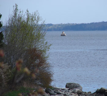
Steele’s Ledge, at the entrance of Belfast Harbor, was named for John Steele, an original proprietor, whose lot sat directly across from the ledge. Today a stone structure with an electric beacon sits on Steele’s Ledge. Tom Seymour Photo
Points of Land
Maine’s coastal geography recalls its early settlers. Names of early residents abound up and down the coast. In many cases, descendents of the people for whom points of land were named not only survive, but in fact live on or near the places for which were named for their ancestors. And for the most part, these place names do appear on modern maps. It’s one thing to allow the name of some remote hill to fade into disuse, but it’s entirely another thing to discontinue a well-recognized name for a peninsula or point of coastal land.
So grab a map or atlas and follow the Maine coast. Notice that some points are named for local flora and fauna, i.e., Spruce Point, Sandy Point and Moose Point, while others reflect family names such as Patterson Point, Kidder Point and Pendleton Point.
Ledges, too, tend to remain with the same name over the course of years. In fact, Steele’s Ledge, at the entrance of Belfast Harbor, was named for John Steele, an original proprietor, whose lot sat directly across from the ledge. Today, a stone structure with an electric beacon, locally known as, “The Monument,” sits on Steele’s Ledge. And, fittingly enough, John Steele’s relatives are buried on a colonial cemetery on the mainland directly opposite The Monument on Steele’s Ledge.
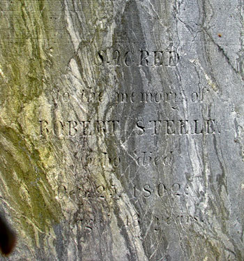
John Steele, an original proprietor whose lot sat directly across from Steele's Ledge. Fittingly enough, John Steele’s relatives are buried in a colonial cemetery on the mainland directly opposite The Monument on Steele’s Ledge. Tom Seymour Photo
Again, for people with an interest in their local history, it is entirely possible to locate much in-depth information on a local place of interest, beginning with only a name.
Mill Names
Mills, too, were once local centers of activity. And mills were named for their owners and operators. Many of these names persist today, although scant few have any memory of how the places got their names. To learn more about the name of any mill(s) in any coastal city or town, just visit the local library, historical society or town historian.
For instance, Williamson’s History, Vol. 1., indicates that the current Poor’s Mills, the name of a road in Belfast, was originally Brown’s Mills, relating to Samuel Brown, who came to Belfast from neighboring New Hampshire and built a sawmill there in 1805. An interesting project for a budding historian would be to find out when Brown’s Mills was changed to Poor’s Mills. Who were the Poor’s? Where did they come from and how long did they live there?
It’s intriguing work, not only for local residents but also for summer visitors with a historical bent.
Another old mill, this time remembered in not only local history, but also as the name of a small church, Mason’s Mills was located on Goose River in Belfast. Does any remnant of the original mill stand today? Several mill sites exist in the area, but to nail down the exact location of Mason’s Mills would require a bit of dedication. The ends would certainly justify the means, however. Such endeavors take us back in time and help to solidify our perspective of just where we are at the moment in the long-range scheme of things.
In Conclusion
Even if you don’t feel compelled to do research on these venerable place names, please remember that these names commemorate some once-living person or persons. In short, place names remain a kind of living legacy to our ancestors.