
Scallop Recovery Spotty
by Laurie Schreiber
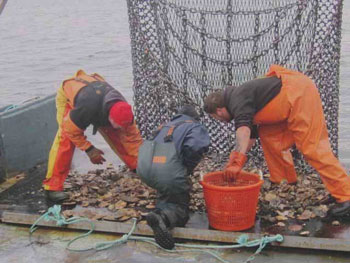
A new report, “Results from the 2011 Maine Sea Scallop Survey,” was released by the Department of Marine Resources on Aug. 3 Photo Courtesy of Department of Marine Resources.
WEST BOOTHBAY – A survey of the inshore scallop resource, conducted in 2011, shows that some areas closed to scallop fishing realized increases in harvestable abundance, but others did not.
According to “Results from the 2011 Maine Sea Scallop Survey,” released by Department of Marine Resources on Aug. 3, the Gouldsboro Bay and Blue Hill closures realized increases in harvestable scallop abundance between 2008 and 2011. Harvestable biomass within Gouldsboro Bay increased over seven times during that period.
Four eastern Maine closures, between Cutler and Stonington, had 1.5-2.5 times higher overall scallop densities than adjacent open areas.
Density of harvestable scallops within the Machias closure was nearly two times higher than the adjacent open area.
But two of the eastern closures (Mount Desert and Lower Jericho Bay) had poor densities and did not realize any increase in abundance, the report says.
The purpose of the survey was “to characterize and monitor the sea scallop resource within Maine’s coastal waters, and to compare results to previous years’ surveys in light of regulatory and environmental changes,” according to the report. “It is necessary to monitor changes in abundance and stock size from year to year to evaluate effects of the fishery, document recruitment events and determine what is available for harvest. The survey provides information needed to evaluate management strategies such as harvest limits and area closures. The survey provides information on geographic distribution, relative abundance, population size structure, meat yield and occurrence of seed and sublegal scallops as well as estimates of harvestable biomass.”
Thirteen areas along the Maine coast were closed by the DMR to scallop fishing in 2009. The closures expired this year.
According to the report, a priority of the 2011 survey was to provide assessments of 11 of these areas. The remaining two were part of a separate 2011 survey in Cobscook Bay/St. Croix River.
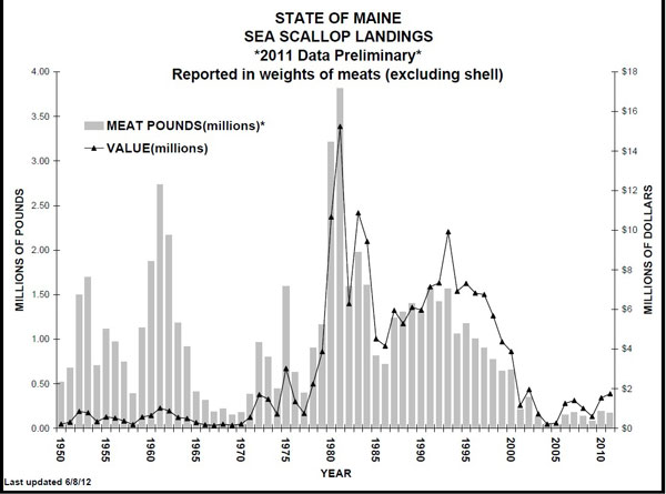
This DMR chart shows Maine scallop landings from 1950 to 2011.
Findings:
• Mount Desert closure: 20 tows, 15 contained no scallops. Overall scallop density was very low. The outside (further offshore) portion of this closure had no scallops. Virtually the only presence of scallops was inside of Sutton Island.
• East Blue Hill Bay to Frenchman Bay: 18 tows completed in the open portion of this stratum, 9 had no scallops. There was a slight increase in overall density between 2008 and 2011. Harvestable density increased somewhat. Sublegals were the dominant size class. Seed abundance was very low.
• Gouldsboro Bay closure: 12 tows completed, 1 contained no scallops. Mean overall density increased significantly since 2008. The largest increase was in harvestable scallops. Sublegal scallops increased somewhat. Seed abundance did not change significantly. Estimated harvestable biomass increased over 7 times between 2008 and 2011.
• Schoodic Point to Great Wass Island: 33 tows completed in the open portion, 19 had no scallops. Overall abundance remained low and was essentially unchanged since 2008.
• The Reach closure: 12 tows, 8 contained no scallops. Overall density was somewhat higher than in the open portion. The predominant size class was sublegal. Harvestable density was somewhat higher than the open area but less than the nearby Chandler Bay closure. There was a slightly greater abundance of seed in the closure than outside, although there was less seed abundance than in the Chandler Bay closure.
• Chandler Bay closure: 9 tows completed, four contained no scallops. Overall density, harvestable density and seed density were slightly greater than in the adjacent open area. No scallops were present in the eastern part of the closure but there was a small aggregation of both seed and harvestables in the western part.
• Great Wass Island to Great Head: 27 stations completed in the open portion. Total density in 2011 was somewhat greater than 2008. The predominant size group was sublegals. Seed density increased somewhat from 2008.
• Machias closure: 21 tows, three contained no scallops. Harvestable density was somewhat greater in the closure than the adjacent open area. There was barely an occurrence of seed in this area.
• Great Head to West Quoddy Head: 16 stations sampled. Mean total abundance, seed density, and harvestable density increased somewhat from 2008 to 2011.
• Lower Jericho Bay closure: 17 tows, 16 contained no scallops. Density was extremely low.
• East Penobscot Bay to West Blue Hill Bay: 7 tows, one contained no scallops. Overall density did not change significantly since 2008. There was no significant change in the densities of either sublegal or harvestable scallops and barely any seed were present.
• East Penobscot Bay closure: 16 stations completed, five had no scallops. Overall density was somewhat higher in the closure than in the adjacent open portion.
• Blue Hill closure: 21 tows, five contained no scallops. Mean overall density was higher in the closure than in the adjacent open area. Overall density also increased. Harvestables were the dominant size class in the closed area, and were significantly higher there than in the open area. There was a higher abundance of harvestables in 2011 than in 2008, an increase of nearly five times. Sublegal abundance did not change significantly from 2008, and seed density was negligible.
• Matinicus Island: 9 stations completed, four contained no scallops.
Overall density remained very low.
• Muscongus Bay/West Penobscot Bay closure: 34 stations: Fourteen tows were made in the West Penobscot Bay portion and five contained no scallops. Twenty tows were made in the Muscongus Bay section and five contained no scallops. Eleven of the Muscongus Bay tows were done in March 2012 since lobster gear prevented their completion in November 2011. Total density was significantly higher in 2011 than 2009. The harvestable size group increased by nearly five times. Sublegals increased somewhat. Seed abundance remained low.
• Damariscotta River/Sheepscot River closure: 17 tows completed, six other tows could not be done due to lobster gear. Nine completed tows had no scallops. Scallop density varied widely. Abundance appeared to increase, particularly within the harvestable size class, but the increase was not statistically significant.
• Casco Bay closure: 13 tows, five others could not be made due to lobster gear and four of the completed tows had no scallops. Overall abundance appeared to increase from 2009, but data varied widely, and the change was not statistically significant. Harvestables were the predominant size group and their abundance increased.
The survey was carried out in November 2011, prior to the Dec. 17, 2011, opening of the fishery, between West Quoddy Head and Matinicus Island, including intensive sampling of the eight closed areas and adjacent open areas. The three closed areas between West Penobscot Bay and Casco Bay were also surveyed.
Scallop currently supports a 70-day commercial fishery along coastal Maine during December to March each year. Maine 2011 landings of scallop meats were approximately 0.18 million lbs. with an ex-vessel value of $1.75 million. The primary gear type is the dredge, although Maine also permits commercial and non-commercial harvest of scallops by diving. There were 818 commercial scallop licenses issued in Maine in 2010 (683 drag and 135 dive) with around 200 of them considered “active” based on catch reports.
On Aug. 9, the DMR hosted a scallop industry meeting to gather input for a final proposed regulation for the management of the resource in the western part of the state.
At the June 29 meeting in Ellsworth, the DMR’s Scallop Advisory Committee recommended the implementation of scallop zones, allowing for different management strategies to be employed in different areas of the state with the common goal of rebuilding the resource, according to information from the DMR. “The western part of the state was designated as “Zone 1” and encompasses coastal areas from the New Hampshire boarder to Penobscot Bay, utilizing the Sea Urchin Zone line running down the middle of Penobscot Bay as the delineator between Zone 1 and Zone 2,” the DMR said. “For Zone 1 (Western Maine), the SAC recommend the retention of the current closed areas as “Limited Access Areas” with 1-2 days week harvest, a 185-pound daily limit, a 70-day season and potentially new, smaller closures.”
According to the minutes from the Aug. 9 meeting, the proposed rule is expected to go out to public comment in late August/early September.
Earlier this year, the DMR and the SAC, discussions around the fishery’s management centered on the idea of continued closures on a rotational basis, and management strategies once the closed areas open up.
“We want an all-encompassing and long-term plan for the fishery,” DMR resource coordinator Trisha DeGraaf told a gathering of about 50 fishermen in April, during one of four meetings hosted by the DMR with members of the scallop industry to discuss management options for the 2012-2013 season.
According to information from the DMR, Maine’s scallop resource is considered to be overfished, with fishery participants limited to a short winter season. Total landings for the scallop fishery peaked in 1981 at around 4 million pounds, valued at $15 million. Since 2003, landings have been less than 200,000 pounds, which is 4 percent of historic landings.
The conservation closures were considered an integral part of the state’s rebuilding plan. The closures represented 20 percent of Maine’s state waters.